866-535-6051

Biking in Banff

mountain biking in Banff

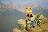
Biking through the trails and roadways is an excellent way to enjoy the sights and cool climate of Banff National Park. This varied terrain and dramatic descents of the Canadian Rockies provide great opportunities to two-wheel your way through dense forests, beside lush meadows, across rocky streams, and along rolling hillsides.

Trails etch their way in and around Banff’s surrounding mountains, but the town itself also provides a great venue for road touring. It's easy to cruise the Banff strip thanks to a network of “sharrow” lanes, which allow bikes to navigate safely through Banff Avenue to Cougar, Squirrel and Elk Street and continue in and out of town. There are numerous shops and outfitters that can provide bike rentals, trail maps, and any other necessary equipment.

Whether you’re a downhill enthusiast, a dedicated road racer, or just looking for a casual and scenic ride through the quaint streets or striking mountainside, Banff has a trail to suit your needs.

Banff Area Trails

  • Sundance – 3.7 km one way, elevation gain 30 m, easy
  • Healy Creek – 4.8 km one way, elevation gain 20 m, easy
  • Brewster Creek – 36.8 km one way, elevation gain 1000 m, difficult
  • Spray River Loop – 12.5 km, elevation gain 200 m, easy
  • Spray River and Goat Creek – 19 km one way, elevation gain 360 m, moderate
  • Rundle Riverside – 14 km one way, elevation gain 180 m, moderate
  • Cascade Ponds - Bankhead – 2.5 km one way, elevation gain 100 m, easy
  • Cascade Ponds - Watertower – 4.2 km one way, elevation gain 120 m, moderate
  • Lake Minnewanka – 30 km one way, elevation gain 75 m, difficult
  • Cascade – 14 km one way, elevation gain 180 m, moderate
  • Upper Stoney Squaw – 2 km one way, elevation gain 150 m, difficult
  • Lower Stoney Squaw – 5.2 km one way, elevation loss 170 m, moderate
  • Redearth –12 km one way, elevation gain 320 m, moderate

Banff Road Rides

  • Mt. Norquay Road – 7.5 km one way, difficult
  • Lake Minnewanka Road – 24 km loop, moderate
  • Tunnel Mt. Drive – 15 km loop, moderate
  • Golf Course Drive – 15 km loop, easy
  • Vermilion Lakes – 5.7 km one way, easy
  • Hwy 1A Fireside Picnic Area to Castle Jct. – 27 km one way, moderate